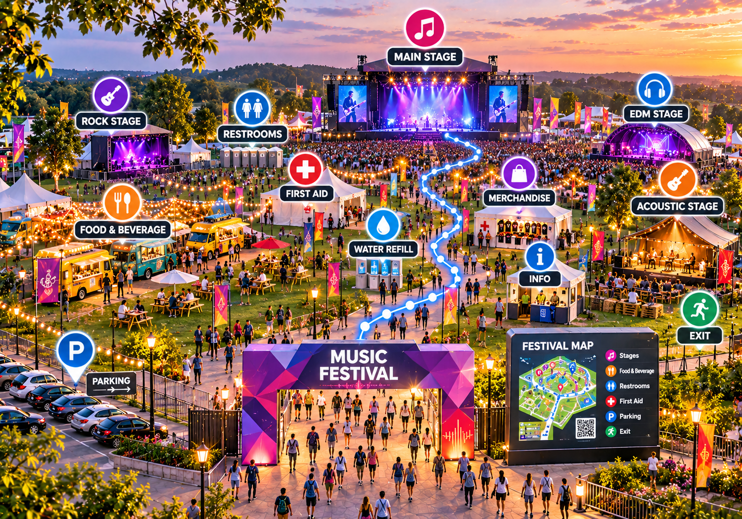
Interactive Maps for Music Festivals: Help Attendees Find Stages and Facilities
Discover how interactive music festival maps help attendees locate stages, food stalls, restrooms, entrances, parking areas, and other essential facilities for a smoother festival experience.
Attending an international music festival, multi-day summer concert, or outdoor cultural event is meant to be a thrilling, memorable experience. However, for many festival-goers, arriving at a sprawling outdoor venue brings unexpected navigation challenges. Trying to find specific music stages, locating food vendors, finding restrooms, pinpointing water refill stations, or identifying designated parking areas across vast festival grounds often leads to lost time, frustration, and missed artist sets.
Festival-goers routinely navigate massive outdoor fields, temporary structures, crowded walkways, and unfamiliar layouts. Without clear visual direction, finding essential services—such as first-aid stations, information booths, merchandise tents, or specific exits—can turn an exciting day into an exhausting search.
Implementing interactive maps for music festivals offers a practical, modern approach to event navigation. By digitising venue layouts and making interactive site plans accessible on mobile devices, festival organisers, production teams, and event management companies can organise location data, streamline attendee navigation, and deliver a smooth, enjoyable event experience.
What Is an Interactive Map for a Music Festival?
An interactive music festival map is a digital visual representation of an event venue that displays performance stages, food and beverage stalls, restrooms, entrances, exits, parking areas, medical posts, and other essential facilities in an organised layout.
Unlike static paper maps or flat image files printed on event flyers, digital festival maps allow attendees to view the full venue layout, zoom into specific performance zones, search for vendor locations or stages, and tap points of interest (POIs) to review location details, such as vendor descriptions or facility guidelines.
A Real-World Example
Consider a festival-goer attending a major three-day outdoor event featuring five separate music stages. The attendee wants to move from the main stage to a smaller electronic music tent on the opposite side of the venue while grabbing a quick bite to eat along the way. Instead of guessing their way through crowded walkways or stopping to read static entrance boards, the attendee opens the festival’s digital map on their smartphone or scans a QR code on a venue sign. They filter the map by "Food & Beverage", select a nearby vendor area, check the location of the electronic music tent, and follow a clear visual path across the grounds.
Why Music Festivals Need Better Attendee Navigation
Managing spatial orientation across sprawling outdoor festival grounds presents distinct operational and communication challenges:
-
Multiple Performance Stages & Concurrent Sets: Outdoor festivals feature multiple stages operating simultaneously across extensive venues, making it easy for attendees to lose their sense of direction.
-
Vast Distances & Complex Pathways: Festival sites frequently span multi-acre parks, fields, or racecourses connected by winding pedestrian paths and temporary fencing.
-
Large Crowds & Visual Barriers: Dense crowds, large stage structures, merchandise tents, and sponsor activations obscure physical sightlines, making landmark navigation difficult.
-
Locating High-Demand Amenities: Quick access to restrooms, free drinking water stations, shade zones, and food courts is essential for attendee health and comfort.
-
Finding Entrances, Exits & Transport Hubs: Identifying main gates, emergency exits, rideshare pickup zones, shuttle stops, and parking lots during day and night hours is critical for smooth crowd flow.
-
Outdated Printed Brochures: Paper site guides degrade easily in outdoor weather, cannot be updated if site layouts change mid-event, and add to venue litter.
Providing clear, accessible location details helps eliminate confusion, allowing visitors to spend less time searching for facilities and more time enjoying live music.
Key Benefits of Interactive Maps for Music Festivals
Adopting digital wayfinding solutions for live music events delivers practical advantages for festival-goers and event management teams alike:
1. Help Attendees Find Music Stages Easily
Clearly labelled performance stages and music zones help attendees locate specific set areas quickly, preventing missed artist performances and reducing confusion across large sites.
2. Make Food and Beverage Areas Easier to Find
Mapping food trucks, dining halls, beverage booths, and dietary-specific vendors helps visitors locate refreshment areas without wandering aimlessly through crowded plazas.
3. Help Visitors Locate Restrooms and Essential Facilities
Clearly identifying restroom banks, handwashing units, water refill stations, and baby-care areas significantly improves visitor comfort and convenience.
4. Improve Entrance, Exit, and Parking Discovery
Marking main gates, VIP entrances, rideshare pickup spots, shuttle drop-offs, and parking zones helps attendees plan their arrival and departure routes efficiently.
5. Make Festival Grounds Easier to Explore
A clear visual overview gives attendees spatial awareness of the venue, helping them understand how different stages, pathways, and activity hubs connect.
6. Help Attendees Discover More Festival Activities
Digital map markers introduce visitors to sponsor activations, artisan markets, art installations, chill-out zones, and official merchandise tents they might otherwise miss.
7. Support Better Event Information Sharing
Event production teams can publish a centralised digital layout accessible via web links or QR codes, ensuring consistent spatial information across official event channels.
8. Support a More Organised Festival Experience
Organised location categories reduce bottlenecks around main entrances and information desks by enabling self-service navigation for tech-savvy festival-goers.
What Should a Music Festival Map Include?
Event organisers should curate a comprehensive list of location markers and details when designing a digital festival map:
-
Event Layout & Boundary Overview: Clean graphic site representations showing venue boundaries, main walkways, and open fields.
-
Main & Secondary Stages: Clearly named performance areas matching official festival line-up schedules.
-
DJ & Electronic Music Tents: Specialised performance zones, dance arenas, and acoustic stages.
-
Food Courts & Vendor Stalls: Dining areas, food truck hubs, vegetarian/vegan vendor indicators, and beverage bars.
-
Restrooms & Water Refill Stations: Restroom banks, accessible facilities, and free drinking water points.
-
Main Entrances, Exits & Ticketing: Access gates, wristband pickup counters, box offices, and VIP entrance portals.
-
Parking, Shuttles & Rideshare Zones: Visitor parking decks, designated rideshare drop-offs, taxi stands, and shuttle stops.
-
First-Aid & Medical Posts: Clearly marked medical stations and welfare tents aligned with official venue safety protocols.
-
Information Desks & Lost and Found: Customer service counters, lost-and-found hubs, and phone charging stations.
-
Merchandise & Sponsor Areas: Official band merchandise tents, vendor markets, and brand activation hubs.
-
Camping & Camping Amenities: Tent fields, RV zones, shower blocks, and cooking areas, if applicable.
-
Accessible Routes & Viewing Platforms: Step-free paths, accessible viewing platforms, and accessible facilities.
Event Safety Note: Safety-related information—such as first-aid locations, security posts, and emergency exits—must be accurate, verified, and coordinated directly with the festival's official safety management plan.
Interactive Festival Maps vs. Traditional Printed Festival Maps
While physical overview boards and pocket paper guides provide basic visual reference, digital interactive maps offer distinct operational and user-experience advantages:
| Feature | Traditional Printed Map | Interactive Digital Map image_b59cdc.png+ 1 |
| Viewing Festival Layout | Fixed, static overview panel on paper or boards |
Interactive visual layout viewable on mobile screens |
| Finding Performance Stages | Relies on small printed graphics and colour keys |
Searchable stage markers with category filters |
| Locating Food Stalls | Limited text space; generic vendor labels |
Categorised vendor pins with menus or descriptions |
| Finding Restrooms | Basic static symbols on printed sheets |
Highlighted facility markers are easily found on mobile. |
| Updating Event Information | Impossible after printing; leads to outdated info |
Digital content can be updated online when site details change. |
| Sharing with Attendees | Requires physical distribution at gates or booths |
Shareable via website URLs, web links, and QR codes |
| Accessing Additional Details | Restricted to printed paper space |
Rich pop-up profiles with details, links, or notes |
How to Create an Interactive Map for a Music Festival
Creating a digital map for a live music event follows a practical, structured process:
Step 1: Collect the Festival Site Layout
Obtain an accurate vector site plan, CAD layout, or high-resolution site diagram from the event production or venue management team.
Step 2: Identify Important Festival Locations
Compile a complete list of performance stages, food vendor hubs, beverage bars, restroom banks, medical tents, parking lots, and entrances.
Step 3: Organise Locations Into Categories
Group points of interest into intuitive categories (e.g., Stages, Food & Drink, Restrooms & Water, Medical & Info, Parking & Transport).
Step 4: Prepare the Digital Map
Select a web-first mapping platform that supports your venue graphics, mobile display goals, and customisation needs.
Step 5: Add Location Labels and Details
Plot pins, upload vendor descriptions, add stage names matching official schedules, and customise colours to match festival branding.
Step 6: Test the Map Before the Event
Test the map across mobile smartphones, tablets, and desktop browsers to verify label legibility, category filtering, marker placement accuracy, and mobile performance.
Step 7: Publish and Share the Map
Deploy the map by embedding it on the official festival website, adding direct links to pre-event email guides, and placing QR codes on venue signage.
Step 8: Keep Festival Information Updated
Review mapped locations whenever stage assignments shift, vendor placements change, or temporary pathway adjustments occur.
How Event Organizers Can Use Digital Festival Maps
Digital venue maps serve as versatile communication tools for festival operations and marketing teams:
-
Guiding Attendees to Stages: Enable visitors to locate specific music stages, acoustic tents, and performance arenas directly from their phones.
-
Promoting Food & Beverage Vendors: Highlight dining areas, food truck courts, craft beverage bars, and dietary options to increase vendor visibility.
-
Clarifying Entrance & Parking Flow: Direct traffic to designated parking zones, rideshare pickup hubs, shuttle pick-up spots, and main entrance gates.
-
Orienting First-Time Visitors: Give attendees an immediate visual overview of sprawling outdoor grounds upon arrival.
-
Supporting Pre-Event Planning: Publish the interactive site plan on the festival website prior to doors opening so attendees can plan their arrival and set schedules in advance.
Note: Interactive digital maps complement—rather than replace—official event announcements, physical signposts, and trained on-site staff assistance.
Best Practices for Designing an Effective Music Festival Map
To ensure a digital festival map delivers maximum value during a busy event, organizers should follow these core design recommendations:
-
Use Standard Stage Names: Ensure stage labels on the map match physical stage banners and published line-up schedules exactly.
-
Design Mobile-First: Choose legible typography, high-contrast colors, and touch-friendly buttons optimized for outdoor viewing on smartphone screens.
-
Organize Categories Intuitively: Group locations logically so attendees can filter by Stages, Dining, Restrooms, or Assistance effortlessly.
-
Highlight Essential Welfare Amenities: Clearly mark free water refill stations, first-aid posts, shade pavilions, and welfare tents.
-
Keep Layouts Uncluttered: Avoid overcrowding the visual map screen with unnecessary decorative graphics that hide paths or stage pins.
-
Verify Location Accuracy: Conduct an on-site walkthrough prior to gate opening to confirm digital pins align with physical stages and facilities.
-
Coordinate Safety Information: Ensure emergency exit pathways, medical posts, and security hubs align accurately with official event safety documentation.
Common Mistakes to Avoid When Creating Festival Maps
When setting up a digital event map, avoid these common implementation pitfalls:
-
Publishing Outdated Site Layouts: Using draft site plans that fail to reflect last-minute stage relocations or fence line adjustments creates confusion.
-
Inconsistent Stage Naming: Labeling a stage "Main Stage" on the map while physical banners read "Apex Arena" misleads attendees.
-
Omitting Essential Amenities: Forgetting to mark water refill stations or medical posts impairs attendee welfare.
-
Neglecting Mobile Usability: Failing to test map load times and touch controls on mobile browsers leads to poor user experiences outdoors.
-
Overcomplicating Categories: Creating dozens of confusing sub-categories makes finding a simple food vendor or restroom bank frustrating.
-
Failing to Update Content: Leaving map errors uncorrected after site setup damages attendee trust in digital guides.
How to Choose Interactive Mapping Software for Music Festivals
Event production teams and festival managers evaluating digital mapping platforms should compare solutions against key operational criteria:
-
Mobile Web Performance: The platform must load fast and run smoothly in standard mobile web browsers across iOS and Android without forcing attendees to download a native application.
-
Ease of Content Management: Look for an intuitive management dashboard that lets non-technical staff add stage pins, edit vendor details, and update locations easily.
-
Search & Category Filtering: Robust search tools capable of matching stage names, vendor types, and amenity keywords (e.g., "Water" or "Medical").
-
Customization & Branding: Options to apply custom brand colors, custom map markers, fonts, and official festival logos.
-
Embedding & Sharing Options: Simple options to embed interactive maps into event websites, mobile guides, and generate shareable web links or QR codes.
-
Platform Reliability & Support: Dependable cloud hosting capable of handling high visitor web traffic during peak event hours, backed by transparent pricing and support.
How eMap.live Fits Into a Music Festival Mapping Workflow
For festival organizers, event management companies, and production teams seeking an efficient way to build and share digital venue layouts, eMap.live provides a flexible, web-based interactive mapping platform.
By visiting https://emap.live/, event teams can explore how the platform supports outdoor venue and event mapping use cases. Verified platform capabilities relevant to music festivals include:
-
Custom Interactive Layout Creation: Transform architectural site drawings or graphic layouts into clean, mobile-friendly interactive maps featuring clickable stage markers and amenity pins.
-
App-Free Mobile Access: Maps run directly inside standard mobile web browsers on iOS and Android devices, allowing attendees to view site layouts instantly without app store downloads.
-
Searchable Directories & Categories: Organize festival locations into custom searchable categories (e.g., Music Stages, Food & Drink, Restrooms & Water, Parking), making it simple for attendees to find specific facilities.
-
QR Code & Web Link Sharing: Easily generate shareable web links and QR codes to place on entrance gate signage, posters, wristband inserts, or event websites.
-
Simple Dashboard Management: Edit stage labels, update vendor descriptions, or adjust facility pins quickly through an easy-to-use web dashboard without coding skills.
Event planners should visit eMap.live to review current feature sets, supported map file formats, and customization options to determine how the platform fits their specific festival mapping workflow.
Frequently Asked Questions
1. What is an interactive map for a music festival?
An interactive map for a music festival is a digital, mobile-responsive visual guide that displays performance stages, food stalls, restrooms, entrances, parking areas, and essential facilities. Accessible via web browsers, it helps attendees navigate event grounds easily.
2. How do interactive maps help music festival attendees?
Digital maps provide searchable location databases and clear visual markers directly on mobile devices. Attendees can locate music stages, find food vendors, pinpoint water refill stations, and identify restrooms without getting lost.
3. What should a music festival map include?
A music festival map should include performance stages, food and beverage zones, restrooms, water refill stations, main entrances, emergency exits, parking zones, medical posts, information desks, merchandise stalls, and accessible viewing areas.
4. Can interactive maps show multiple festival stages?
Yes. Digital mapping platforms allow event organizers to plot and label multiple music stages, acoustic tents, and DJ arenas, making specific performance zones easy to search and find on-screen.
5. How can attendees find food stalls and restrooms at festivals?
Attendees can open the festival's digital map on their smartphone, filter by categories (e.g., Food & Drink, Restrooms), or search for specific vendor names to view exact visual locations across the grounds.
6. Can QR codes be used to share music festival maps?
Yes. Event organizers can generate QR codes linked directly to their interactive map URL. Placing these QR codes on entrance banners, schedule booklets, or wristband cards allows attendees to launch the map instantly on their phones.
7. How can event organizers create an interactive festival map?
Organizers can create a map by obtaining a site layout, compiling location details, categorizing stages and amenities, uploading graphics to an interactive map platform like eMap.live, adding pins and descriptions, testing mobile display, and sharing via QR codes or links.
8. Why are digital maps useful for large outdoor music festivals?
Digital maps give attendees an immediate visual overview of large outdoor fields and complex layouts, helping them understand spatial connections between distant stages, camping fields, and transport hubs.
9. Can festival maps show entrances and parking areas?
Yes. Digital maps can highlight main entrance gates, VIP portals, visitor parking lots, rideshare drop-off zones, and shuttle pickup points to streamline arrival and departure traffic.
10. What should organizers consider when choosing festival mapping software?
Organizers should evaluate software based on mobile web performance, ease of content updates, custom branding options, category search capabilities, QR code support, cloud reliability, and transparent pricing.
11. Can an interactive festival map replace on-site event staff?
No. Digital maps complement—rather than replace—on-site security personnel, customer service staff, physical directional signage, and official safety announcements.
Conclusion: Make Music Festivals Easier to Explore
Clear, accessible spatial guidance is essential to modern music festival management. As outdoor events expand and attendees expect digital self-service solutions, traditional paper brochures and static billboard maps alone no longer guide visitors effectively.
Interactive maps for music festivals bridge the gap between physical event layouts and digital convenience. By organizing performance stages, publishing searchable amenity directories, highlighting welfare facilities, and providing mobile web access via QR codes, event organisers can eliminate spatial confusion and elevate the overall live event experience.
Ready to make your music festival easier to navigate? Explore eMap.live to evaluate how its web-based interactive mapping platform can support your event's navigation strategy.
