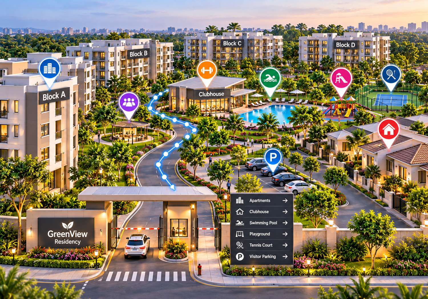
Interactive Maps for Residential Communities: Improve Resident Navigation
Discover how interactive residential community maps help residents and visitors locate homes, building entrances, parking areas, amenities, and shared facilities with greater ease.
Moving into or visiting a modern residential community should be a welcoming experience. However, as housing developments, gated estates, and multi-building apartment complexes grow in scale, finding a specific home or facility can become surprisingly difficult. Navigating sprawling neighbourhoods featuring similar-looking apartment blocks, winding internal roads, separate vehicle gates, and secluded recreational amenities frequently leads to frustration, delayed deliveries, and lost visitors.
Residents, guests, delivery personnel, service contractors, and emergency responders routinely arrive on-site with only a house number or building code. Without clear spatial guidance, identifying the correct entrance, locating visitor parking, or finding shared facilities like the clubhouse or pool can turn a routine arrival into an annoying hassle.
Implementing interactive maps for residential communities offers a practical, modern approach to property navigation. By digitising community layouts and making interactive site plans accessible on mobile devices and desktop web pages, property managers and homeowners' associations (HOAs) can organise location data, streamline visitor arrivals, and elevate the overall living experience.
What Is an Interactive Map for a Residential Community?
An interactive residential community map is a digital, visual representation of a housing estate, apartment complex, or gated development that displays residential blocks, house numbers, internal roads, entrances, parking zones, and shared amenities in an organised format.
Unlike flat paper brochures or static metal site boards at entrance gates, digital community maps enable users to view the entire neighbourhood layout, zoom into specific residential sections, search for building numbers or amenities, and tap points of interest (POIs) to review location details, such as visitor access rules, opening hours, or contact links.
A Real-World Example
Imagine a new resident trying to locate the community fitness centre for an early morning workout, or a first-time guest driving into a 500-unit gated estate to visit a friend in "Block D, Building 3". Instead of driving in circles or stopping at security gates to ask for directions, the visitor opens the community's digital map on their smartphone or scans a QR code at the main security kiosk. They type "Block D" or select "Clubhouse & Gym" from the amenity directory, view the exact location alongside designated visitor parking areas, and navigate directly to their destination without stress.
Why Residential Communities Need Better Navigation
Managing spatial navigation across expanding residential properties presents distinct operational challenges for property managers, HOAs, and residents:
-
Sprawling Properties & Complex Road Layouts: Master-planned developments and gated estates often feature winding cul-de-sacs, circular drives, and multiple internal streets that confuse first-time visitors.
-
Identical Architectural Blocks: Multi-building apartment complexes frequently feature identical building facades, making it difficult to distinguish "Building 7" from "Building 8" at night or from a distance.
-
Multiple Vehicle & Pedestrian Gates: Gated communities often designate separate gates for residents, visitors, commercial deliveries, and construction traffic.
-
Hidden Shared Amenities: Facilities like swimming pools, tennis courts, barbecue pavilions, parks, playgrounds, and waste disposal stations are often tucked away behind residential blocks.
-
High Volume of Daily Delivery Drivers: E-commerce, food delivery, and courier drivers operating under tight schedules require immediate visual clarity to locate specific building entrances and drop-off points quickly.
-
Outdated Physical Directories: Printed maps at entrance gates weather quickly, become outdated when facility rules change, and cannot be consulted while driving through the property.
-
Remote Direction Sharing: Residents frequently struggle to explain complex internal driving routes to visiting friends, family members, or service contractors over the phone.
Clear, accurate, and easily accessible location data helps eliminate spatial uncertainty, ensuring safer, faster, and more convenient navigation for everyone on-site.
Key Benefits of Interactive Maps for Residential Communities
Adopting digital wayfinding for residential properties delivers practical benefits across the entire community ecosystem:
1. Help Residents Find Homes and Buildings
Organised building listings and clearly labelled house numbers mapped to visual property blocks allow residents, guests, and emergency services to identify specific addresses quickly. Consistent naming conventions and accurate spatial layouts eliminate guesswork.
2. Make Community Amenities Easier to Locate
Digital maps make it easy for residents and guests to discover and locate shared facilities, including:
-
Clubhouses and community halls
-
Parks, gardens, and walking trails
-
Playgrounds and splash pads
-
Swimming pools and sun decks
-
Fitness centres and sports courts
-
Convenience stores, cafés, and retail kiosks
-
Dog parks and recycling centres
3. Improve Visitor Navigation
First-time guests benefit from clear information regarding main entrance gates, visitor reception kiosks, designated guest parking bays, and pedestrian pathways, ensuring a smooth arrival experience.
4. Support Delivery and Service Access
Accurate building labels and mapped entrance points help couriers, food delivery drivers, maintenance technicians, and utility contractors locate drop-off zones and service doors efficiently.
5. Improve Access to Parking and Entrances
Visual maps highlight visitor parking zones, resident-only parking decks, EV charging stations, pedestrian gates, and vehicle exits, reducing improper parking and traffic congestion along internal streets.
6. Help New Residents Understand the Community
An organised digital map provides onboarding support for new homeowners and tenants, helping them familiarise themselves with the property layout, nearby amenities, and internal road connections during their first weeks.
7. Help Property Managers Organise Location Information
Digital mapping tools provide property management companies and HOAs with a centralised format to present property details, building numbers, and amenity guidelines consistently without reprinting physical signs.
What Should a Residential Community Map Include?
Property administrators should curate a comprehensive checklist of location markers and details when setting up their interactive digital map:
-
Community Name & Master Site Layout: Clear visual graphics displaying overall property boundaries, main roads, and neighbourhood sectors.
-
Residential Blocks & Building Numbers: Searchable identifiers for individual houses, apartment blocks, villas, or townhouse clusters.
-
Main Entrances, Visitor Gates & Exits: Clearly marked vehicle access points, security check-in booths, and resident keycard gates.
-
Visitor & Resident Parking Areas: Designated visual markers for guest parking bays, covered resident decks, and EV charging ports.
-
Parks, Green Spaces & Playgrounds: Mapped outlines of recreational lawns, walking loops, and children's play areas.
-
Clubhouses & Sports Facilities: Locations for community centres, swimming pools, gyms, tennis courts, and function rooms.
-
Property Management & Maintenance Offices: On-site administration counters, security offices, and package pickup rooms.
-
Accessible Routes & Entrances: Verified step-free pathways, ramps, and accessible parking bays for mobility-impaired residents.
-
Emergency Assembly Points: Verified safety zones and evacuation assembly areas approved by facility management.
Privacy & Security Note: Property managers must prioritize resident privacy when publishing community maps. Avoid publicly displaying sensitive resident names, private apartment occupancy details, gate access codes, or internal security camera placements. Maps should focus on spatial orientation, building labels, visitor access, and public amenities.
Interactive Maps vs. Traditional Residential Layout Maps
While static paper handouts and entrance monument boards provide basic physical landmarks, digital interactive maps offer significant functional and operational advantages.
| Feature | Traditional Static Map (Print/Board) | Interactive Digital Map image_b59cdc.png+ 1 |
| Viewing the Community Layout | Fixed, static 2D overview panel at gates |
Interactive visual layout viewable on mobile devices |
| Identifying Residential Buildings | Relies on small printed text and colour keys |
Clickable visual markers with searchable building labels |
| Locating Shared Amenities | Limited to static symbols on a board |
Categorised overlays for pools, gyms, parks, and clubhouses |
| Updating Information | Requires physical reprinting and sign replacement |
Digital map content can be updated online instantly. |
| Accessing Location Details | Restricted to concise text labels on physical signs |
Rich pop-up profiles with amenity hours, rules, and links |
| Sharing with Visitors | Requires physical handouts or photo screenshots |
Shareable digitally via web links, URLs, and QR codes |
| Mobile Access | Handheld paper sheet or entrance billboard |
Responsive web view accessible on smartphones and tablets |
How to Create an Interactive Map for a Residential Community
Building an interactive map for a housing development or apartment complex follows a practical, structured implementation process:
Step 1: Collect the Community Layout
Gather an accurate site vector plan, CAD drawing, or high-resolution architectural layout representing the property’s building footprints, roads, pedestrian paths, and amenity zones.
Step 2: Organise Residential Locations
Compile a standardized list of residential blocks, building numbers, and house ranges. Ensure street names and block identifiers match physical concourse signage exactly.
Step 3: Identify Important Amenities
Determine which shared facilities residents and guests search for most often (e.g., Clubhouse, Visitor Parking, Pool, Gym, Management Office) and group them into intuitive categories.
Step 4: Prepare the Map
Select a web-first mapping platform that supports your property layout, image formats, customisation requirements, and mobile display goals.
Step 5: Add Labels and Location Details
Plot points of interest, upload amenity descriptions, add building labels, and apply custom brand colors matching the community's visual identity.
Step 6: Test the Map
Test the map across mobile smartphones, tablets, and desktop browsers to verify label clarity, search responsiveness, touch controls, and marker accuracy.
Step 7: Publish and Share the Map
Deploy the map by embedding it on the HOA or property management website, sharing the link in resident welcome portals, and displaying QR codes at security gates and entrance lobbies.
Step 8: Keep the Map Updated
Establish a routine schedule to review and update map details whenever amenities undergo maintenance, parking rules change, or management offices relocate.
How Property Managers Can Use Interactive Community Maps
Digital mapping solutions serve as valuable operational tools for residential property management teams:
-
Streamlining Visitor Arrival: Security personnel at main entrance gates can share map QR codes with arriving guests, reducing gate queues and manual direction-giving.
-
Enhancing Resident Onboarding: Welcome packages for new homeowners and tenants can include a digital map link to help them discover amenities and services immediately.
-
Organizing Multi-Building Estates: Property managers handling dozens of apartment blocks can maintain a clean, centralized digital directory accessible to all residents.
-
Guiding Service Contractors: Maintenance teams, landscapers, utility workers, and waste management crews can locate specific utility rooms, building blocks, and service entrances quickly.
-
Promoting Community Amenities: Showcasing parks, fitness centers, and event halls on a digital map highlights property value for current residents and prospective buyers during site tours.
Best Practices for Designing an Effective Residential Community Map
To ensure a digital residential map provides maximum value, property managers should follow these core design recommendations:
-
Use Consistent Building Names: Ensure digital labels match physical house numbers, building blocks, and street signs precisely.
-
Design for Mobile Screen Readability: Choose clear typography, high-contrast colors, and touch-friendly interface elements optimized for smartphone viewing in bright outdoor sunlight.
-
Organize Amenities Intuitively: Group locations into simple categories (e.g., Residential Blocks, Recreation & Parks, Parking & Entrances, Management & Services).
-
Highlight Visitor Parking & Entrances: Clearly distinguish guest parking bays and main entrance gates from resident-only areas.
-
Keep Layouts Uncluttered: Avoid overcrowding the visual map screen with unnecessary decorative graphics that hide roads or building labels.
-
Protect Resident Privacy: Never publish private resident names, phone numbers, or apartment occupancy details on public map portals.
-
Verify Accuracy Before Publishing: Conduct an on-site physical walk-through to confirm that map pins align accurately with physical buildings and roads.
-
Provide Clear Contact Options: Include a link or email address where residents can report incorrect building labels or broken facility links.
Common Mistakes to Avoid
When setting up a digital community map, avoid these common implementation mistakes:
-
Publishing Outdated Property Plans: Using old site plans that omit newly constructed buildings or modified internal roads creates confusion.
-
Inconsistent Building Identifiers: Labeling a structure "Building B" on the map while physical signage reads "Block 2" confuses arriving visitors.
-
Neglecting Mobile Usability: Failing to test how the map displays on mobile web browsers leads to poor touch interaction for guests scanning QR codes at gates.
-
Omitting Visitor Entrances: Showing building locations without marking where guests should actually park or enter causes unnecessary traffic in resident zones.
-
Exposing Restricted Data: Including private resident information, security passcodes, or internal camera positions compromises community safety.
-
Failing to Maintain Map Content: Leaving seasonal amenity hours or temporary road closure notices unupdated damages resident trust in the platform.
How to Choose Mapping Software for a Residential Community
Property managers and HOA administrators evaluating digital mapping platforms should compare software against key operational requirements:
-
Mobile Web Performance: The platform must load fast and run smoothly in mobile web browsers across iOS and Android without forcing users to install a native app.
-
Ease of Map Content Management: Look for an intuitive management dashboard that lets non-technical staff add building pins, edit descriptions, and update category details easily.
-
Search & Category Capabilities: Robust search tools capable of matching building numbers, block names, and amenity keywords (e.g., "Gym" or "Visitor Gate").
-
Customization & Branding: Options to apply custom brand colors, custom map markers, fonts, and property logos.
-
Embedding & Sharing Flexibility: Simple options to embed interactive maps into HOA web pages, resident portals, and generate shareable web links or QR codes.
-
Pricing & Platform Reliability: Dependable cloud hosting capable of handling high visitor web traffic during peak hours, backed by transparent pricing and technical support.
How eMap.live Fits Into an Interactive Mapping Workflow
For residential developers, HOA boards, and property managers seeking an efficient way to build and share digital site plans, eMap.live provides a flexible, web-based interactive mapping platform.
By visiting eMap, property administrators can explore how the platform supports residential property and neighborhood mapping use cases. Verified platform capabilities relevant to residential communities include:
-
Custom Interactive Layout Creation: Transform architectural site drawings and vector floor plans into clean, mobile-friendly interactive maps featuring clickable building markers and amenity pins.
-
App-Free Mobile Access: Maps run directly inside standard mobile web browsers on iOS and Android devices, allowing guests and residents to view property layouts instantly without app store downloads.
-
Searchable Directories & Categories: Organize residential blocks, guest parking, and recreational facilities into custom searchable categories (e.g., Apartment Blocks, Parks & Pools, Gates & Parking, Management).
-
QR Code & Web Link Sharing: Easily generate shareable web links and QR codes to place on entrance gate signage, welcome packets, or community websites.
-
Simple Dashboard Management: Edit building labels, update amenity opening hours, or adjust facility descriptions quickly through an easy-to-use web dashboard without coding skills.
Property managers should visit eMap.live to review current feature sets, supported map file formats, and customization options to determine how the platform fits their specific residential mapping workflow.
Frequently Asked Questions
1. What is an interactive map for a residential community?
An interactive map for a residential community is a digital, mobile-responsive visual guide that displays building layouts, house numbers, roads, entrances, parking areas, and shared amenities. Accessible via web browsers, it helps residents and visitors navigate housing developments easily.
2. How do interactive maps improve resident navigation?
Digital maps provide searchable location databases and clear visual markers directly on mobile devices. Residents and guests can locate specific building blocks, find visitor parking, and discover amenities like gyms or pools without getting lost.
3. What should a residential community map include?
A residential community map should include residential building blocks, house numbers, main entrance gates, visitor parking zones, parks, clubhouses, swimming pools, fitness centers, pedestrian paths, and property management offices.
4. Can interactive maps show apartment buildings and house numbers?
Yes. Digital mapping platforms allow property administrators to plot and label individual apartment blocks, house numbers, and villa clusters, making specific addresses easy to search and find visual locations for on-screen.
5. How can visitors find amenities in a large residential community?
Visitors can open the community's digital map on their smartphone, filter by amenity categories (e.g., Recreation, Clubhouse, Parks), or search for specific facilities by keyword to view exact visual locations and nearby parking bays.
6. Can QR codes be used to share residential community maps?
Yes. Property managers can generate QR codes linked directly to their interactive map URL. Placing these QR codes at security gates, entrance lobbies, or welcome flyers allows visitors to launch the map instantly on their phones.
7. How can property managers create a digital residential community map?
Property managers can create a map by collecting a site plan, organizing building labels and amenity categories, uploading graphics to an interactive map platform like eMap.live, adding pins and descriptions, testing mobile performance, and sharing via QR codes or web links.
8. Are interactive maps suitable for gated communities?
Yes. Interactive maps are ideal for gated communities because they help visitors navigate winding internal roads and find designated guest parking, provided that private resident information and access codes remain protected.
9. How often should residential community maps be updated?
Community maps should be updated whenever building numbers change, new amenity rules or hours take effect, temporary road maintenance occurs, or property management offices relocate.
10. How can eMap.live be used for residential community mapping?
eMap.live enables property managers to convert site drawings into searchable, mobile-responsive interactive maps featuring custom amenity categories, clickable building markers, and QR code sharing options.
Conclusion: Make Residential Communities Easier to Navigate
Providing clear, accessible spatial guidance is an essential part of modern residential property management. As housing developments, gated estates, and apartment complexes grow larger, static paper flyers and physical entrance boards alone are no longer sufficient to guide residents, guests, and delivery drivers effectively.
Interactive maps for residential communities bridge the gap between physical property architecture and digital self-service convenience. By organising building layouts, publishing searchable amenity directories, protecting resident privacy, and providing mobile web access via QR codes, property managers can eliminate spatial confusion and elevate the overall community living experience.
Ready to make your residential property easier to navigate? Explore eMap.live to evaluate how its web-based interactive mapping platform can support your community's navigation strategy.
