How QR Code Maps Improve Visitor Navigation: A Complete Guide (2026)
Discover how QR code maps simplify visitor navigation, provide instant access to digital maps, and enhance experiences at events, campuses, sports complexes, and public venues.
Introduction
Modern visitors expect quick and convenient access to information wherever they go. Whether they are attending a high-profile industry conference, visiting a sprawling university campus, exploring a massive sports complex, or walking through an expansive public park, people want simple, friction-free navigation tools that help them reach their destinations efficiently.
Traditional printed maps often create more challenges than they solve. They become outdated the moment venue layouts change, are increasingly expensive to print, and can be frustratingly difficult for visitors to manipulate and read on the move. This is why forward-thinking organizations are aggressively adopting QR code maps as a foundational element of their digital wayfinding strategies.
QR code maps allow visitors to instantly access interactive digital maps by simply scanning a QR code with their smartphone camera. These maps provide real-time navigation, searchable locations, and up-to-date information, creating a significantly better visitor experience.
In this comprehensive guide, we'll explore exactly how QR code maps improve visitor navigation and why they have become an essential tool for modern venues in 2026.
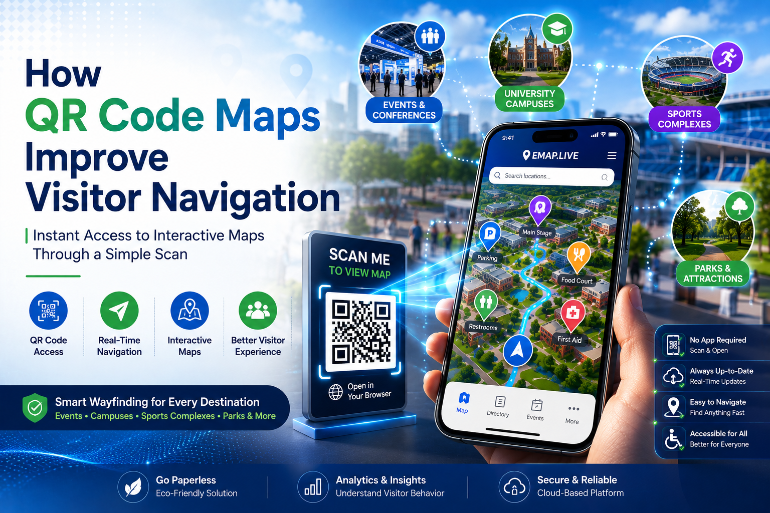
What Are QR Code Maps?
QR code maps are dynamic, interactive digital maps that are hosted in the cloud and accessed instantly by scanning a Quick Response (QR) code using a standard smartphone camera.
Instead of ordering, storing, and handing out thousands of physical, printed paper maps, organizations strategically place QR codes at high-traffic touchpoints, such as:
-
Main entrance gates and ticketing windows
-
Parking lots and rideshare drop-off zones
-
Information kiosks and security desks
-
Event registration tables
-
Campus building lobbies
-
Stadium concourses and entry gates
Upon arrival, visitors simply point their phone camera at the code and instantly launch a feature-rich, interactive map directly within their native mobile browser.
The Ultimate Convenience: Absolutely no app store download is required. This eliminates a massive barrier to entry, resulting in drastically higher adoption rates among visitors.
How QR Code Maps Work
The transition from physical architecture to digital wayfinding is remarkably straightforward, operating on a simple four-step process:
Step 1: QR Code Placement
Organizations generate unique, high-contrast QR codes that are securely linked to their custom digital map URLs. These codes are integrated directly into physical signage, posters, dynamic displays, or visitor badges.
Step 2: Visitor Scans the Code
A visitor approaches the signage and opens the native camera application on their smartphone. The device instantly detects the QR code and presents a clickable web link.
Step 3: The Digital Map Opens
The user taps the link, and the interactive venue map automatically renders in their mobile web browser (such as Safari or Chrome) within seconds, bypassing the friction of app installations.
Step 4: Navigation Begins
The visitor can immediately utilize a smart search bar to find points of interest, view optimized walking routes, and fluidly navigate the multi-level or outdoor venue in real time.
Why QR Code Maps Are Becoming Popular
Several macro shifts in technology and consumer behavior are driving the rapid adoption of QR navigation systems:
-
Ubiquitous Smartphone Usage: Nearly every modern visitor already carries a highly capable smartphone equipped with a native QR code scanner.
-
Preference for Contactless Experiences: Post-pandemic behavior has cemented a strong visitor preference for touch-free, sanitary access to public information.
-
Demand for Real-Time Data: People expect immediate answers. If a schedule shifts or an area closes, digital maps reflect that change instantly.
-
Aggressive Sustainability Goals: Modern organizations are under strict corporate mandates to eliminate paper waste and shrink their carbon footprint.
-
Elevated Experience Standards: Consumer expectations are shaped by seamless apps; giving them an interactive map makes venue navigation feel fast, modern, and entirely frictionless.
Key Benefits of QR Code Maps
Instant Access to Navigation
Visitors do not have to struggle with large, unfolding paper sheets or spend time searching an app store. One quick, two-second scan provides immediate entry to a fully tailored navigational suite.
Drastically Reduced Printing Costs
Organizations completely wipe out the recurring financial overhead associated with designing, proofing, printing, shipping, and recycling paper maps.
Real-Time Cloud Updates
Whether it is an unexpected closure, a shift in an exhibitor's booth location, or a sudden change to an event schedule, administrators can deploy updates instantly without replacing any physical signage.
Improved Visitor Experience
By taking the guesswork out of wayfinding, venues minimize crowd frustration, prevent bottlenecking in corridors, and allow visitors to spend less time getting lost and more time engaging with the venue's core offerings.
Mobile-Friendly Responsive Design
Advanced mapping software ensures that the maps load rapidly, scale properly, and remain perfectly readable across a massive matrix of iOS and Android devices.
Enhanced Accessibility
Unlike static paper, interactive digital maps can actively guide users with limited mobility by highlighting accessible entrances, elevators, ramps, dedicated ADA parking structures, designated restrooms, and flat emergency exit pathways.
Highly Environmentally Friendly
Transitioning to digital architecture completely eliminates paper usage, aligning modern enterprises directly with global green initiatives.
Where QR Code Maps Are Actively Used
Events and Conferences
Event organizers utilize QR codes on badge lanyards and entrance banners to help thousands of rotating trade show attendees quickly pinpoint concurrent session rooms, specific exhibitor booths, crowded food courts, and registration zones.
Sports Complexes and Stadiums
Tens of thousands of sports fans scan QR codes pinned to the backs of stadium seats or concourse pillars to find their exact seating sections, nearby concession stands, team merchandise stores, and preferred exit gates.
University Campuses
Incoming freshmen, parents, and visiting professors scan codes at major campus quadrangles to seamlessly orient themselves across dozens of academic buildings, multi-level libraries, student dormitories, and administrative offices.
Parks and Recreation Areas
State parks and wildlife preserves position weather-resistant QR codes at trailheads and intersections, allowing hikers to safely map out winding trails, find scenic attractions, pinpoint picnic areas, and locate ranger stations.
Corporate Campuses
Multi-building tech and enterprise corporate campuses leverage QR code wayfinding to assist new hires, visiting clients, and external vendors in locating specific offices, meeting rooms, and campus amenities.
QR Code Maps vs. Traditional Printed Maps
| Feature | QR Code Maps | Printed Maps |
| Real-Time Updates | Yes, instant cloud synchronization | No, requires a full reprint cycle |
| Mobile Access | Yes, right on the user's phone | No, requires carrying physical paper |
| Search Functionality | Yes, quick keyword searching | No, requires manual eye scanning |
| Printing Costs | None, completely digital | High, recurring operational expense |
| Accessibility Features | Yes, fully customizable routes | Limited to static symbols |
| User Analytics | Yes, tracks popular paths & searches | No, completely anonymous usage |
| Environmental Impact | Extremely Low, paperless | High, recurring resource waste |
Best Practices for Deploying QR Code Maps
To maximize the overall adoption rate and effectiveness of your digital wayfinding system, ensure you execute these proven industry practices:
-
Place QR Codes Strategically: Position your codes at logical, high-traffic friction points where people naturally slow down to orient themselves—such as main entrance thresholds, parking garages, elevator banks, information desks, and major structural intersections.
-
Ensure Flawless Mobile Optimization: Choose a professional mapping platform that ensures your maps are lightweight, fast-loading, and completely responsive on all mobile viewports.
-
Use Clear, Actionable Signage: Never display a floating QR code without context. Use clear, bold text commands next to the code, such as: "Scan Here to Open the Interactive Map & Find Your Way."
-
Keep Map Information Maintained: Assign a team member to manage the backend dashboard. Ensure all room assignments, point-of-interest labels, and operational hours strictly reflect live venue conditions.
-
Include Smart Search Features: A map is only as good as its findability. Ensure your user interface features an intuitive, highly visible search bar that auto-suggests locations as the visitor types.
The Future of QR Code Navigation
As we move through 2026 and look toward the future, QR code maps are evolving far beyond simple 2D overhead layouts. Venues are actively blending QR access points with advanced technological layers to redefine spatial exploration:
-
Precision Indoor Positioning: Merging QR start-points with Wi-Fi triangulation and Bluetooth Low Energy (BLE) beacons to provide blue-dot, turn-by-turn indoor navigation across multi-story buildings.
-
Augmented Reality (AR) Directions: Overlaying digital, glowing arrow pathways directly onto the live physical environment viewed through the smartphone camera screen upon scanning.
-
Hyper-Personalised Visitor Experiences: Integrating the map with customer schedules to automatically generate optimized daily paths based on their specific calendar or ticket tier.
-
Real-Time Crowd Management: Dynamic re-routing algorithms that gently guide visitors away from congested choke points or long concession lines toward quieter routes.
Frequently Asked Questions
What exactly are QR code maps?
QR code maps are modern, cloud-based interactive digital maps that users can pull up instantly on their mobile devices by scanning an on-site, physical QR code with their smartphone camera.
Do visitors need to download a specialized app to use them?
No. High-quality interactive mapping platforms allow the map to launch instantly within the smartphone’s native mobile web browser, eliminating the friction of app store downloads.
Why are QR code maps superior to printed paper alternatives?
They offer dynamic keyword searching, support instant real-time information updates, allow for inclusive accessibility routing, capture valuable behavioral analytics, and completely eliminate recurring printing expenses.
Can QR code navigation systems track user behavior?
Yes, but purely anonymously. Administrators can track aggregated metrics such as the most searched rooms, frequently viewed points of interest, and peak scanning times to strategically optimize venue layouts.
What happens if the venue layout or room schedules change?
An administrator can log into a centralized cloud dashboard, apply the structural or text changes, and publish them. The very next visitor to scan the QR code will instantly view the updated map layout.
Conclusion
QR code maps have fundamentally transformed modern visitor navigation by providing instant, frictionless access to powerful digital layouts through a simple, universal smartphone scan.
By prioritizing digital wayfinding, organizations can drastically streamline crowd movement, erase high printing overheads, support strict eco-friendly sustainability initiatives, and deliver a vastly superior, memorable experience across events, university campuses, sports complexes, parks, and corporate facilities.
As digital wayfinding rapidly establishes itself as the mandatory standard in 2026, implementing QR code maps is proving to be one of the single most cost-effective and highly impactful tools for helping visitors confidently and independently navigate any environment.
What type of venue or space are you managing, and what is the biggest navigation bottleneck your visitors currently run into?