Best Campus Navigation App for Universities in 2026
Discover how modern campus navigation apps help students, faculty, staff, and visitors easily navigate university campuses with interactive maps, QR code access, and real-time wayfinding.
Introduction
Modern university campuses are larger, busier, and more complex than ever before. Many institutions span hundreds of acres and include an intricate network of academic buildings, residence halls, multi-level libraries, sprawling sports facilities, massive parking structures, research centers, and scattered student service offices.
For incoming freshmen, anxious parents, newly hired faculty, out-of-town visitors, and event attendees, navigating these vast collegiate environments can be deeply overwhelming.
Traditional campus paper maps, printed informational brochures, and static PDF files completely fail to provide the dynamic guidance users actually need on the move. They quickly become outdated due to ongoing campus construction, are notoriously difficult to manipulate on mobile screens, and fail to provide real-time spatial information.
This is exactly why high-forward institutions are increasingly adopting dedicated campus navigation apps.
Interactive campus navigation apps empower students and visitors to find precise buildings, individual classrooms, open parking zones, specific event venues, and essential student support services directly from their smartphones. By delivering real-time wayfinding and highly detailed interactive maps, universities can significantly improve the overall campus experience.
In this comprehensive guide, we'll explore exactly what makes the best campus navigation app and why leading universities are aggressively investing in digital wayfinding solutions in 2026.
What Is a Campus Navigation App?
A campus navigation app is a cloud-based, mobile-optimized digital mapping solution designed specifically to help users navigate complex university geography and indoor layouts efficiently.
Instead of relying on clunky, folding paper charts or unclickable PDFs, users can load interactive maps that instantly reveal:
-
Precise building locations and historical names
-
Granular classroom, laboratory, and lecture hall data
-
Dynamic parking lot availability and permit guidance
-
Optimized walking, biking, and campus shuttle directions
-
Live locations for campus-wide events and orientations
-
Essential campus services like student health centers and dining halls
-
Advanced, step-free accessibility routes for users with limited mobility
By consolidating geospatial layout mapping with live school data, these platforms turn a chaotic first day on campus into a stress-free digital experience.
Why Universities Need Campus Navigation Apps
Universities operate like miniature cities, serving tens of thousands of active students, faculty, staff, and visitors every single day. Without an effective, modern navigation tool in place, individuals frequently waste precious time struggling to track down critical locations, including:
-
Academic halls and breakout seminar rooms
-
Lecture halls tucked deep inside massive complexes
-
Multi-floor libraries and study lounges
-
Centralized student unions and dining hubs
-
Permit-specific parking areas and transit stops
-
Sports arenas, stadiums, and training facilities
-
Administrative, registrar, and financial aid offices
This spatial confusion leads to unnecessary multi-user delays, late arrivals to exams, traffic jams in campus garages, and pervasive visitor frustration. Campus navigation apps eliminate these organizational bottlenecks by giving users immediate access to highly accurate location tracking.
Common Campus Navigation Challenges
Large and Evolving Campus Layouts
Many higher education systems consist of dozens of historically or geographically separated architectural styles spread across massive regions. It historically takes weeks for new students to memorize their paths and avoid getting lost between consecutive classes.
High Visitor Confusion
Parents, seasonal guests, external conference attendees, and prospective high school students touring the grounds have zero familiarity with localized acronyms or structural nicknames.
Complex Multi-Location Event Navigation
Universities act as cultural hubs, regularly hosting large-scale events that attract massive crowds who need immediate assistance, such as:
-
Freshman orientation weeks
-
Spring and fall graduation ceremonies
-
High-traffic stadium athletic events
-
Regional academic conferences
-
Sprawling career fairs and business expos
Parking and Transit Friction
Finding an open parking space that aligns with a specific visitor pass or student permit tier can be exceptionally difficult, especially during high-stress exam periods or peak event hours.
Stringent Accessibility Requirements
Institutions are legally and ethically obligated to provide smooth, inclusive, and equitable routing for individuals with diverse physical, visual, or mobility challenges.
Top Features of the Best Campus Navigation Apps
When evaluating a digital mapping vendor for your university, ensure the software platform prioritizes these core high-performance features:
-
Dynamic Interactive Campus Graphics: The application should allow users to fluidly zoom, pan, tilt, and shift between distinct campus layers or architectural levels without layout distortion.
-
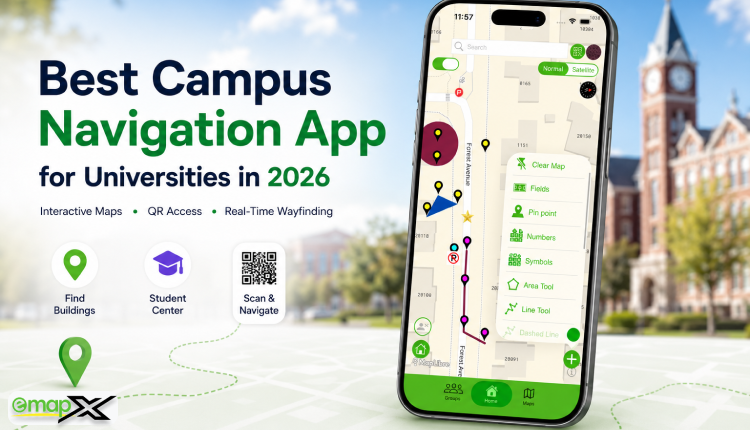
App-Free QR Code Access: Universities can place distinct QR codes directly on physical signposts at main campus gates, perimeter parking lots, student centers, and libraries. Visitors simply point their smartphone camera at the sign and instantly open the live map directly in their native web browser—no app store download or login account required.
-
Intelligent Keyword Search Bar: Users must be able to type in building codes, specific classroom numbers, department names, or localized facilities and receive an instant suggest-as-you-type directory marker.
-
Real-Time Cloud Synchronization: University administrators need a robust, unified dashboard to instantly update building details, mark temporary construction zone closures, adjust transit shuttle routes, or pin active pop-up events.
-
Mobile-First Responsive UI: Because students and guests are utilising the software while actively walking, the map interface must load lightning-fast and remain responsive across all iOS and Android devices.
-
Advanced Accessibility Integration: The best campus wayfinding applications feature advanced filters that map out specialised step-free routes, indoor elevator positions, ramp layouts, ADA-compliant entrances, and dedicated accessible parking spaces.
Tangible Benefits of Going Digital
For Students
-
Accelerated Navigation: Students cut down walking friction, meaning they spend less time searching for hidden seminar rooms and more time focused on their actual academics.
-
Dramatically Reduced Stress: Incoming freshmen can confidently transition to college life without the mental anxiety of feeling completely lost in a massive crowd.
-
Streamlined Onboarding: Interactive orientation maps take the logistical friction out of welcome week, allowing students to focus on building new social connections.
-
Frictionless Resource Discovery: Undergraduates can effortlessly locate campus student resources, counseling centers, tutoring labs, and dining spaces they otherwise might have completely overlooked.
For Visitors
Because visitors carry zero baseline familiarity with the university landscape, they benefit immensely from digital wayfinding. A clean interface guides them seamlessly to admissions offices, performance venues, athletic ticket gates, and guest parking zones, cementing a highly positive and welcoming first impression of the institution.
For University Administrators
-
Elevated Institutional Reputability: Delivering premium, high-tech navigational tools reflects positively on the university's brand and technological adoption.
-
Drastically Fewer Routine Inquiries: Front-line staff, academic advisers, and campus security spend significantly less time pointing out basic direction requests.
-
Optimized Crowd and Traffic Management: Digital maps let administrators distribute foot and vehicle traffic evenly across alternative routes, ensuring safety during massive events.
-
Modern Innovation Image: Deploying beautiful digital wayfinding explicitly showcases the institution’s commitment to tech-driven infrastructure leadership.
Interactive Maps vs. Traditional Campus Maps
| Feature | Live Interactive Maps | Legacy Printed/PDF Maps |
| Real-Time Updates | Yes, instant cloud synchronization | No, requires an expensive redesign cycle |
| Search Bar Tool | Yes, instant building & room lookup | No, requires manual eye scanning |
| Mobile Accessibility | Excellent responsive web layout | Limited clunky pinch-to-zoom scrolling |
| QR Code Access | Yes, launches instantly via web browser | No, completely offline manual medium |
| Accessibility Support | Advanced, dedicated route filters | Basic, limited static symbol markings |
| Wayfinding Analytics | Yes, tracks popular search terms & spots | No, completely unmeasurable usage |
| User Experience | High, fluid, personalized, and rapid | Moderate, frequently confusing to read |
How emapX Live Transforms University Campuses
Platforms like emapX - Live Custom Maps are actively empowering academic institutions to entirely leave behind the constraints of traditional printed sheets and clunky, non-searchable PDF floor plans. With emapX Live, university administrators can design highly custom, white-labeled interactive digital worlds that radically simplify how the public interacts with their campus physical space.
Key enterprise advantages of the emapX Live platform include the following:
-
Stunning, cross-device interactive campus visual layouts
-
Rapid, flexible QR code navigation deployments at main entry doors
-
Instant, real-time cloud data modifications and building detail updates
-
Advanced search directories that map both outdoor paths and indoor rooms
-
Complete White-Label custom design controls to match official university branding
-
Multi-location account management to support satellite and regional campuses from a single hub
-
Direct website embedding to elevate the prospective student web portal experience
The Future of Campus Wayfinding
As universities look deeper into 2026 and beyond, campus navigation apps are acting as the necessary spatial foundation for next-generation consumer technologies. Forward-thinking institutions are already laying the framework to blend map apps with precision indoor blue-dot positioning systems, augmented reality (AR) walking arrows that appear through a live camera feed, and AI-powered personalized class schedule routing paths that automatically track a student's canvas calendar.
Frequently Asked Questions
What exactly is a campus navigation app?
A campus navigation app is a mobile-responsive digital solution that maps out a university's entire physical footprint, allowing users to search for and navigate directly to buildings, classrooms, offices, parking decks, and student amenities.
Why are interactive maps better than traditional downloadable campus PDFs?
Unlike flat PDFs, interactive maps offer predictive search bars, render beautifully across all mobile viewports without endless manual zooming, capture aggregated crowd flow analytics, and update instantly via the cloud.
Do users need to download a heavy app from the app store to view the map?
No. Using modern solutions like emapX Live, universities can link the map straight to an open web URL. Students and guests simply scan an on-site QR code to open the full interactive map instantly within their phone's native browser.
Can campus navigation apps highlight accessible paths for individuals with disabilities?
Yes. Top-tier platforms include advanced accessibility layers that actively map out step-free sidewalks, ramp entries, elevator banks, ADA-compliant doors, and designated accessible parking zones.
How much time does it take to deploy a layout update if a building closes for maintenance?
It takes mere seconds. An authorized campus administrator simply logs into a secure cloud backend dashboard, alters the specific room or lane information, and hits publish to push the change live to all active devices instantly.
Conclusion
As modern university campuses continue to break spatial records in physical size and operational complexity, providing a friction-free navigation strategy has become more crucial than ever before.
Campus navigation apps allow institutions to seamlessly guide students and visitors to their destinations faster, reduce crowd confusion, ensure inclusive accessibility compliance, and cultivate a truly modern, tech-forward presence. With advanced features like live interactive layers, app-free QR code deployment, instant cloud administration, and responsive mobile architecture, digital wayfinding stands out as a critical tool for successful university management.
For higher education institutions looking to completely modernize their campus wayfinding experience in 2026, implementing a scalable solution like emapX Live provides the ultimate path to elevate how people explore, discover, and interact with your campus environment.
Is your university managing an open-air historical campus or a dense, multi-level urban environment? Let us know your layout and the biggest wayfinding bottleneck your student body encounters!