Why Event Organizers Are Replacing PDF Maps with Live Interactive Maps
Discover why event planners are moving beyond static PDF maps and adopting live interactive maps to improve attendee navigation, engagement, and event experiences.
Introduction
For years, PDF maps have been a standard tool for helping attendees navigate conferences, trade shows, festivals, sports tournaments, university events, and large public gatherings. Event organizers would create venue layouts, export them as PDFs, and distribute them through websites, emails, registration packets, or printed handouts.
While PDF maps served their purpose, attendee expectations have changed encounters dramatically. Today's visitors expect instant access to information, mobile-friendly navigation, real-time updates, and seamless digital experiences. As a result, event organizers worldwide are replacing static PDF maps with live interactive maps.
Live interactive maps offer dynamic navigation, QR code access, searchable locations, and real-time updates that significantly improve the attendee experience while reducing operational challenges for organizers. In this article, we'll explore why interactive maps are becoming the preferred choice for modern events in 2026.
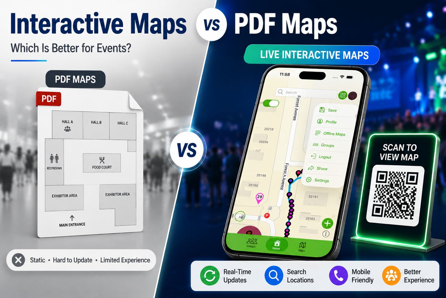
The Problem with Traditional PDF Maps
PDF maps may appear simple and convenient, but they create several hidden challenges for both organizers and attendees.
Static Information
A PDF map is essentially a fixed digital snapshot. Once created and distributed, the information remains completely rigid. If an exhibitor changes booths, a session room shifts at the last minute, or a food vendor relocates due to logistical issues, the PDF immediately becomes an outdated liability.
Difficult Navigation
Visitors often need to zoom in repeatedly, pinch their screens, and pan across a massive file to view fine text or numbers. Finding a specific booth, stage, classroom, or parking area can turn into a deeply frustrating task.
Poor Mobile Experience
The vast majority of modern attendees access event information strictly through smartphones. PDF maps are simply not designed for modern mobile navigation and often require excessive scrolling, leaving users disoriented.
No Search Functionality
Visitors cannot simply query what they need. If they are looking for specific booth numbers, speaker rooms, food courts, parking locations, restrooms, or information desks, they must manually scan the entire layout line by line.
Zero Analytics
Event organizers have no visibility into how people move. They cannot see:
-
Which locations visitors search for most
-
Popular high-traffic destinations
-
Navigational friction points
-
Real-time visitor engagement trends
What Are Live Interactive Maps?
Live interactive maps are dynamic digital solutions that allow users to interact with locations directly through their smartphones, tablets, and desktops.
Unlike static PDF maps, interactive maps provide a rich, unified ecosystem including searchable locations, mobile-friendly navigation, QR code access, real-time updates, interactive wayfinding, rich location details, and backend analytics reporting. Visitors can instantly access maps and navigate venues without downloading large files or struggling with rigid layouts.
Why Event Organizers Are Making the Switch
1. Real-Time Cloud Updates
One of the biggest advantages of live interactive maps is the ability to update information instantly via the cloud. Event organizers can modify session locations, exhibitor booths, vendor spots, parking information, and venue access points in seconds. Changes appear immediately for all visitors without requiring a new PDF to be exported, uploaded, and redistributed.
2. Better Attendee Experience
Attendees want quick, simple, and reliable navigation. Interactive maps help visitors find locations faster, navigate large venues smoothly, discover exhibitors, locate services, and access event information instantly. This directly reduces crowd confusion and improves overall event satisfaction.
3. App-Free QR Code Accessibility
Modern event organizers are increasingly leveraging QR code maps to bridge the physical-to-digital gap. Visitors simply scan a QR code placed on physical signage and instantly access the latest version of the event map in their mobile browser. This means no app store download is required, giving users instant access and drastically reducing support requests at the information desk.
4. Improved Event Engagement
Interactive maps encourage attendees to actively explore their surroundings. Visitors can intuitively click nodes to discover sponsors, exhibitors, attractions, interactive activities, and special event areas they might have otherwise walked past, driving up engagement across the entire venue.
5. Reduced Printing and Design Costs
Printing thousands of physical paper maps as backups for an outdated PDF is highly expensive. Interactive maps eliminate printing costs, distribution fees, reprinting costs due to venue adjustments, and recurring design revision expenses, protecting the organizer's operational budget.
6. Enhanced Sponsor Visibility
Sponsors are a critical financial pillar of modern events. While PDF maps relegate sponsors to a tiny static logo in a corner, interactive maps allow organisers to highlight sponsor locations, feature premium interactive placements, include rich sponsor descriptions, and embed direct promotional links, creating valuable new sponsorship revenue streams.
Live Interactive Maps vs. PDF Maps
| Feature | Live Interactive Maps | PDF Maps |
| Real-Time Updates | Yes, instant cloud sync | No, requires complete file replacement |
| Search Functionality | Yes, instant keyword search | No, requires manual eye scanning |
| Mobile Friendly | Excellent responsive layout | Limited, relies on manual pinch-to-zoom |
| QR Code Access | Yes, scans straight to web browser | No, must host and link the file download |
| Visitor Analytics | Yes, tracks user searches and clicks | No, completely anonymous file downloads |
| Interactive Navigation | Yes, dynamic wayfinding paths | No, flat static visual layout |
| Sponsorship Opportunities | High, clickable ads and rich profiles | Limited to static image placement |
| Printing & Material Costs | None, completely paperless deployment | Ongoing, high recurring paper print fees |
| User Experience | Excellent, intuitive, and modern | Average, clunky on mobile devices |
Events That Benefit Most from Interactive Maps
-
Conferences: Help professional attendees easily locate specific educational sessions, meeting rooms, networking areas, and registration desks.
-
Trade Shows: Visitors can quickly filter and find individual exhibitor booths, live product demonstrations, and main sponsor pavilion areas.
-
Music Festivals: Sprawling festival grounds become easy to navigate, helping fans locate stages, food vendors, public restrooms, and medical first-aid stations.
-
Sports Events: Fans can navigate massive stadiums to find seating sections, parking lots, team merchandise stores, and nearby concession stands.
-
University Events: Help new students, parents, and community visitors easily locate campus buildings, specific classrooms, auditoriums, and open-house activity areas.
How emapX Live Supports Modern Events
Platforms like emapX—Live Custom Maps are helping event organizers move smoothly beyond static PDF maps. With live interactive mapping solutions, organisers can design custom event maps, provide seamless QR code access on physical signage, and update venue information instantly.
Using emapX, managers can easily monetise their maps with sponsor ads and logos, creating an entirely new revenue stream while replacing basic pinned map layouts with a dynamic "live PDF" map experience. This allows events of all sizes, from sports complexes and outdoor festivals to campuses and shopping districts, to operate more efficiently while delivering a modern digital experience.
Future of Event Navigation
The future of event navigation is entirely digital, and interactive maps provide the foundational infrastructure for what comes next. Emerging trends fast approaching standard adoption include:
-
QR-code-driven wayfinding across complex environments
-
Precision indoor positioning systems (IPS)
-
Augmented reality (AR) navigation overlays
-
AI-powered localized recommendation engines
-
Real-time crowd management and congestion routing
Organizations that ditch static PDFs and adopt digital wayfinding software today will be far better prepared to meet tomorrow's visitor expectations.
Frequently Asked Questions
Why are PDF maps becoming less popular?
PDF maps are completely static, incredibly difficult to update instantly, lack a basic search bar, and offer a poor, clunky mobile viewport experience compared to live interactive alternatives.
What are live interactive maps?
Live interactive maps are cloud-hosted, dynamic digital maps that offer attendees advanced search functionality, responsive mobile navigation, app-free QR code access, and real-time layout updates.
How do QR code maps work?
Visitors simply point their smartphone camera at an on-site QR code. The device reads the link and automatically launches the latest, most up-to-date version of the digital venue map right inside their mobile browser.
Can interactive maps improve attendee experience?
Yes. By giving attendees a searchable, responsive interface, they can confidently find destinations faster, discover amenities, and access live schedule changes without frustration.
Are interactive maps better for event organizers?
Absolutely. They cut out high printing and reprinting costs, provide flexible layout management, create higher-tier sponsorship opportunities, and capture valuable backend visitor analytics.
Conclusion
As events grow larger and attendee expectations continue to lean into digital-first convenience, traditional PDF maps are no longer enough to support a premium experience. Live interactive maps provide real-time updates, mobile-friendly navigation, friction-free QR code accessibility, better attendee experiences, and powerful analytics that static PDF maps simply cannot match.
For conferences, festivals, sports tournaments, trade shows, and university events, interactive maps are rapidly cementing themselves as the new standard for modern navigation. In 2026 and beyond, event organizers who confidently embrace live interactive maps will be best positioned to deliver smarter, more efficient, and highly engaging experiences for every attendee.
What kind of map does your venue currently use, and what is the biggest frustration your attendees have reported when trying to find their way?