Best Interactive Mapping Software for Events in 2026
Explore the top event mapping software platforms that help organizers improve navigation, enhance attendee experiences, and streamline event management in 2026.
Introduction
Modern events are becoming significantly larger, more complex, and increasingly focused on delivering exceptional attendee experiences. Whether you are organizing a high-profile industry conference, a sprawling trade show exhibition, a multi-day music festival, a massive sports tournament, a large-scale university orientation, or a global corporate gathering, helping attendees navigate your venue efficiently is essential.
Traditional printed maps often create immense confusion, become outdated the very moment a schedule changes, and completely fail to provide real-time information. That is why event organisers are increasingly turning to dedicated interactive mapping software.
Interactive event maps help attendees find locations, discover points of interest, access live schedules, and navigate venues seamlessly using their smartphones. In 2026, event mapping software has shifted from a premium luxury to a critical, mandatory component of successful event planning and visitor engagement.
This comprehensive guide explores the best interactive mapping software for events, the core features that matter most, and how digital event maps can dramatically improve attendee experiences.
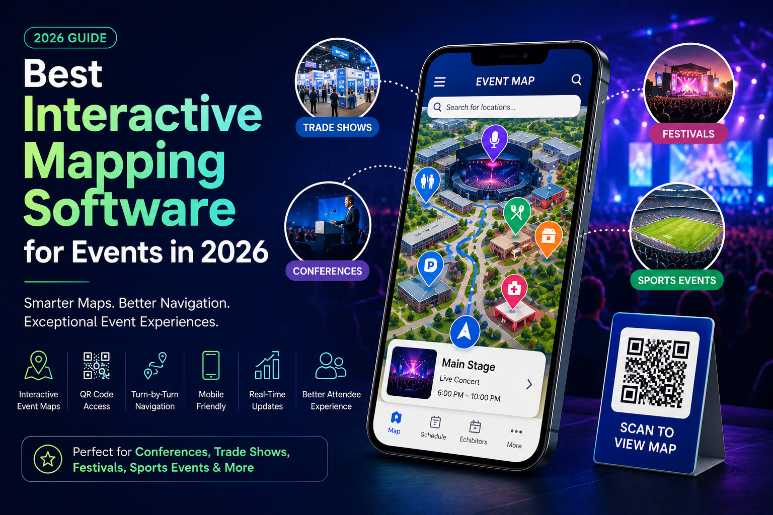
What Is Event Mapping Software?
Event mapping software is a cloud-based digital platform that enables organisers to create interactive, dynamic maps tailored for conferences, festivals, exhibitions, sports events, and complex venues.
Unlike traditional static image maps or paper handouts, interactive event maps allow attendees to:
-
Search complex locations and vendor spaces instantly
-
View hyper-localized event schedules and session timelines
-
Find specific exhibitors, booths, and corporate sponsors
-
Access real-time venue information and security guidelines
-
Navigate indoor and outdoor spaces fluidly using mobile devices
-
Scan physical QR codes for immediate, app-free digital map access
-
Receive critical, real-time updates and emergency alerts
These powerful capabilities make event mapping software one of the most valuable assets in modern event management.
Why Interactive Event Maps Matter in 2026
Today's event attendees expect intuitive, digital-first experiences. People already use their smartphones daily to navigate international airports, multi-level shopping malls, and unfamiliar cities; naturally, they expect that same convenience when attending events.
By adopting interactive event maps, organizers can:
Improve Attendee Navigation
Visitors can quickly locate primary stages, specific booths, designated parking lots, food courts, and restrooms without wandering aimlessly through crowded halls.
Reduce Confusion
Attendees spend significantly less time getting lost or asking event staff for basic directions, allowing them to focus more energy on enjoying the event programming.
Enhance Visitor Experience
Seamless, stress-free navigation directly translates into improved overall satisfaction, higher engagement metrics, and positive event reviews.
Deliver Real-Time Information
Organizers can update venue layouts, booth assignments, or routing instantly when schedules, weather conditions, or spatial locations change on the fly.
Reduce Printing Costs
Transitioning to digital mapping completely eliminates the recurring need to design, print, and distribute thousands of physical paper maps that inevitably end up as waste.
Features to Look for in Event Mapping Software
Not all event mapping solutions offer the same baseline capabilities. When evaluating a platform, here are the most important features to consider:
-
Interactive Venue Maps: Attendees must be able to fluidly zoom, pan, tilt, and interact with specific nodes or locations pinned across the map.
-
QR Code Access: Visitors should be able to scan a QR code on physical venue signage and instantly open the web-based map without an app store download.
-
Mobile-Friendly Design: Maps must be fully responsive, lightweight, and optimized to work perfectly on any smartphone, tablet, or digital information kiosk.
-
Robust Search Functionality: Users should easily find exhibitors, stages, food vendors, parking areas, restrooms, and information desks via keyword typing.
-
Real-Time Updates: Organizers need a reliable backend dashboard to update scheduling information, closures, or booth swaps instantly.
-
Custom Branding: The map interface should match the event's visual identity, supporting custom logos, hex colors, and typography.
-
Analytics and Insights: Understanding anonymous visitor footprint behavior and search history helps managers structurally improve future event layouts.
Best Interactive Mapping Software for Events
1. EMAP Live
EMAP Live stands out as a leading software platform that helps organizations design and deploy interactive maps tailored for events, venues, sports complexes, university campuses, and public parks.
-
Key Features: Highly responsive interactive digital maps, rapid QR code deployment, seamless mobile-friendly experience, instant real-time updates, advanced searchable locations, comprehensive custom branding, and dynamic wayfinding solutions.
-
Best For: B2B and B2C conferences, music festivals, stadium sports events, university orientations, and expansive corporate venues.
2. Event-Specific Mobile Apps
Many comprehensive event management software platforms now bundle basic mapping features directly within their native mobile applications.
-
Advantages: Offers highly integrated schedules, direct push notifications, built-in attendee networking, and proximity-based interactive venue maps.
-
Limitations: Requires a mandatory app download from attendees, suffers from lower adoption rates, and commands significantly higher development and maintenance costs.
3. GIS-Based Mapping Platforms
Advanced Geographic Information System (GIS) solutions can be used by specialized engineering teams to draft highly detailed geospatial event maps.
-
Advantages: Extremely powerful spatial mapping capabilities, extensive geographic analysis data, and infinite custom integrations.
-
Limitations: Exceptionally complex user setup, requires technical expertise, and is fundamentally not designed for fast-paced event organizers.
Benefits of Interactive Event Maps
Better Attendee Experience
Attendees can find what they need quickly and easily, minimizing travel friction between different sessions or halls.
Increased Event Engagement
Visitors are far more likely to explore parts of the venue they otherwise wouldn't discover when layout navigation is made simple and inviting.
Improved Sponsor Visibility
High-value corporate sponsors and custom exhibitor booths become remarkably easier to discover, increasing their foot traffic and visual ROI.
Enhanced Accessibility
Interactive maps can explicitly highlight accessible entrances, elevators, ramps, dedicated ADA parking structures, and specialized restrooms, ensuring an inclusive experience for all.
Higher Operational Efficiency
On-site event staff and security personnel spend less time answering basic navigation questions and can focus on critical logistical tasks.
Use Cases for Event Mapping Software
Conferences and Trade Shows
Help professional attendees efficiently locate concurrent speaker sessions, designated meeting rooms, individual exhibitor booths, and exclusive networking lounges.
Music Festivals
Guide festival-goers safely to various performance stages, sprawling food courts, merchandise tents, water refilling stations, and first-aid medical tents.
Sports Events
Enable sports fans to easily find their exact seating sections, pre-booked parking structures, gate ticket booths, and the nearest concession stands.
University Campuses
Assist incoming students, parents, and visiting alumni in navigating large campus-wide events, open houses, and career fairs across multiple academic buildings.
Corporate Events
Support internal and external guests attending regional meetings, educational seminars, product launches, and private corporate exhibitions.
Interactive Event Maps vs. Printed Maps
| Feature | Interactive Event Maps | Printed Maps |
| Real-Time Updates | Yes, instant cloud distribution | No, requires a complete reprint cycle |
| Mobile Access | Yes, right on the user's phone | No, requires carrying physical paper |
| Search Functionality | Yes, instant keyword search | No, requires manual eye scanning |
| QR Code Integration | Yes, bridges' physical signage | No, completely offline format |
| Visitor Analytics | Yes, tracks popular paths & booths | No, zero visibility into user behavior |
| Printing Costs | None, fully digital infrastructure | Ongoing, high recurring print fees |
| User Experience | Excellent, personalized, and fast | Limited, frequently outdated |
How Event Mapping Software Improves Visitor Experience
Interactive maps systematically remove physical friction from the attendee journey. By providing a clear digital companion, visitors can pre-plan their walking routes before arrival, navigate efficiently during packed event hours, discover hidden attractions, access schedules instantly, and stay informed about emergency layout changes. This creates a smoother, highly memorable experience that attendees reflect on positively.
Why Event Organisers Are Switching to Digital Maps
The global shift toward digital-first experiences continues to accelerate rapidly. Event organisers are aggressively adopting interactive mapping software because it improves spatial navigation, boosts brand engagement, reduces overhead operational costs, supports strict corporate sustainability goals, provides actionable behavioural analytics, and delivers a premium, modern attendee experience. Organisations that invest in digital wayfinding solutions gain a decisive competitive advantage in the event space.
Frequently Asked Questions
What is event mapping software?
Event mapping software is a digital platform used to design, host, and manage interactive maps that help attendees find their way around events, venues, and exhibitions.
Why are interactive event maps important?
They improve real-time navigation, significantly reduce venue confusion, increase sponsor visibility, and elevate the overall attendee experience.
Can QR code maps be used for events?
Yes. Placing QR codes on physical signs allows attendees to scan and access the fully interactive digital map instantly without needing paper materials or app downloads.
What types of events benefit most from interactive maps?
Large-scale conferences, trade shows, music festivals, stadium sports tournaments, university campus events, and multi-building corporate gatherings.
Are interactive event maps mobile-friendly?
Yes. Modern event mapping platforms like EMAP Live are explicitly optimized to run fast and look great on all smartphones and tablets.
Can event maps be updated in real time?
Absolutely. Organizers can instantly change booth locations, highlight closures, or update schedule details directly from a central administrative dashboard.
Conclusion
As events become larger and attendee expectations continue to evolve alongside mobile technology, interactive mapping software has cemented itself as an essential tool for successful event management.
From streamlining crowd navigation and reducing venue confusion to increasing sponsor ROI and delivering real-time schedule information, interactive event maps provide an overwhelming advantage over traditional printed alternatives. Whether you are running a convention, festival, major tournament, campus showcase, or corporate seminar, investing in dedicated event mapping software will help you engineer a seamless, engaging, and memorable experience for every attendee.
In 2026, organizations that actively embrace interactive event maps will be better positioned to deliver modern, visitor-focused experiences while drastically improving their operational efficiency and overall event success.